We are moving on the next Unit.
Now it's time to learn about the relief of our country.
But first we need to review some important concepts.Let's start!
Some information from a web page: enchanted learning:
geography
Geography is the study of the Earth's surface.
physical map

A physical map is a map that shows an areas natural physical features, like mountains, lakes, and rivers.

mountain
A mountain is a very tall high, natural place on Earth - higher than a hill. The tallest mountain on Earth is Mt. Everest.
range
A range is a chain of mountains and/or high elevations.
plateau
A plateau is a large, flat area of land that is higher than the surrounding land
plain
Plains are flat lands that have only small changes in elevation.
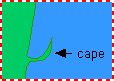
cape
A cape is a pointed piece of land that sticks out into a sea, ocean, lake, or river.
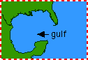
gulf
A gulf is a part of the ocean (or sea) that is partly surrounded by land (it is usually larger than a bay).
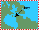
bay
A bay is a body of water that is partly enclosed by land (and is usually smaller than a gulf)

peninsula
A peninsula is a body of land that is surrounded by water on three sides.

island
An island is a piece of land that is surrounded by water.
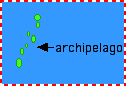
archipelago
An archipelago is a group or chain of islands clustered together in a sea or ocean.

ocean
An ocean is a large body of salt water that surrounds a continent. Oceans cover more the two-thirds of the Earth's surface
sea
A sea is a large body of salty water that is often connected to an ocean. A sea may be partly or completely surrounded by land.
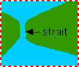
strait
A strait is a narrow body of water that connects two larger bodies of water.
Here I leave some links to review the relief of Spain.
Flash map (Where is it?)
Flash Map (What's the name?
And here a link to word search you can download and print out. WORDSEARCH
This is so much interesting Rosa continue like this rosa please!
ResponderEliminarThank you César!!
EliminarEsto es interesante
ResponderEliminarThanks a lot!!!
Eliminar